|
|
|
Image Quality Checking and Geometric Correction
by : Idung Risdiyanto
MIT Student / Biotrop
1999
![]()
![]()
![]()
Abstract
Digital image from satellites contains errors in geometry and in the measurement brightness values of the pixel. Base on sources, the error digital image can be divided two sections, there are radiometric distortion and geometric distortion. According Richards, J.A (1993), the source of radiometric distortion cause be of the atmosphere effect on radiation, on remote sensing imagery and instrumentation errors. Geometric distortion can arise in many ways. Source geometric distortion including, earth rotation effect, panoramic distortion, earth curvature, scan time skew, variation in platform altitude, velocity and attitude, aspect ratio distortion, sensor scan non linearity.
If
we looked errors based on type, image distortion can be divide systematic and
random errors. Systematic is the
errors can be predictable and corrected at the station receiver.
Example systematic errors, caused by
the eastward rotation of the earth and other errors are dependent upon the type
of sensor. Random errors can not be
predict and corrected by the analyst. Random
errors or non-systematic errors cause by altitude and attitude variations,
topographic effect, no relation of raw image to coordinate system, and noise
cause by sensor and haze (atmosphere effect).
When an images is to use it is frequently necessary to make correction in radiometric and geometric errors if the accuracy of interpretation, either manually or by machine, is not to be prejudiced. For many applications, only the major source of error will required compensation whereas in others more corrections that are precise will be necessary.
Brief
Discussion
The task assignment has purpose to image quality checking, geometric correction and metadata about uncorrected SPOT multiband optical image of Bogor. The problems were encountered while completing the assignment can be divided three bases on the purpose. From all-purpose, some problem was getting from image and other from hardware.
To purpose image quality checking, we can not certain good or best image quality, because we did not have parameters or measure for calibration an image. Especially, in band and colour its. We can see and change band and colour only and we didn’t know an image quality is good or best. So, these problem solve an image quality checking can do using edit transform limit with change digital number (DN) its. From diagram of DN each band, we had done correct of DN in edit transform limit/edit formula.
Geometric correction have done change uncorrected image to correct image. The procedures or method will be georeferenced to corrected and projected layer vector for the same area. Some problems were getting to geometric correction, there are image resolution, determinations of parameters, accuracy of GCPs and hardware (monitor resolution).
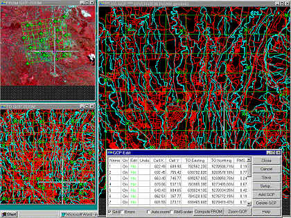
Image resolution cause indifferent object of the image and unclear. Example, between road and stream often indifferent, discontinue of road and stream and crowded of road in urban area. So, road and stream can be defined from main road and main stream or far from urban, example highway. Determination of parameters have getting cause we unknown parameters which define the mathematical equation between the image coordinate system and the geographic coordinate system. We can know from referenced only that the uncorrected raster image and corrected vector image is Bogor area. But, that is enough to geometric correction. Causing from image resolution and determines of parameters we was get problem for collect GCPs. Not all criteria of collect GCPs can be meet. Example, intersection stream and road, between road and bridge, etc. Other hand, year of build SPOT image and corrected layer vector maybe not same, so, if in the uncorrected image we get main road but in the layer vector we can not get. Therefore, at overlay corrected SPOT images within corrected layer vector we meet any point not matching. To solve these, we can collect GCPc from clear curve by stream or main road. Also, support from computer hardware especially monitor resolution. Causing its, we can meet problems of zooming image. So, the accuracy of GCP collected become failed or points not matching. To solve these, we can changes monitor resolution from computer control panel.
Distribution of GCPs should be randomize, but almost equally spaced including corner areas. About ten to twenty points which are clearly identified both on the image and the map should be selected depending on the order of the selected formula or the number of unknown parameters. The accuracy of geometric correction is usually represented by the standard deviation (RMS), in pixel units, in the image plane. GCPs accuracy should be usually within + 1 pixel. If the error is larger than the requirement, the coordinates on the image or map should be rechecked, otherwise the formula should be reselected. In this case, collecting 20 GCPs with average about 0,144 already does rectification. The result of the raw image had been corrected, from the display, the corrected image had been rotated.
 |
Metadata is information you need to
know in order to use the data. Metadata is used for facilitates data sharing,
makes data storage and querying easier, supports easier data access and
management, increase values of data resources, and increase flexibility in using
data. In this case, the data that provided is not complete. We still don’t
know exactly when the data has been taken (date of image and roads and streams).
Conclusion
The assignment task is radiometric and geometric correction of multiband optical data using an uncorrected SPOT multiband optical of Bogor will be georeferenced corrected and projected streams and road vectors for the same area. The task divided some section, there are organised files to prepare image corrected, image quality checking, geometric correction and metadata. The main procedures of image quality checking in this report is edit transform limit, because we didn’t have calibrated parameters and measure about image quality. Procedures of geometric correction use type of rectification is polynomial with polynomial order is linear and resampling is cubic. There are type is using because uncorrected image to correct with the corrected vector layer. Using dataset information we can creating and updating metadata record containing information about the raw data, sensor, spectral bands, processing procedures and dates. The assignment task is necessary, because for interpreted image we must to use best image quality for getting lower interpretation error. The quality is clear image, accuracy of geo-coordinate and complete information from metadata.
|
![]()
![]()
![]()
![]()