|
|
|
Surface Modeling and Analysis Using TIN and Grid Models
created : Idung Risdiyanto
MIT Student/First Year
![]()
![]()
![]()
BACKGROUND
|
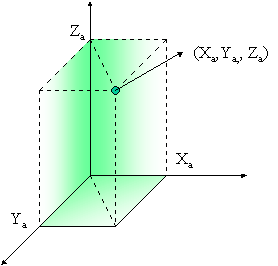
When we create GIS project to natural resources study we need information about situation of surface. It mains, the information have the relationship with surface or be build from third-dimensional function. This fact, only use for continuous data like as rain, elevation, slope etc. So, surface can be defining as presentation continuous spatial phenomena. As third-dimensional function, surface can be presentation into xyz coordinate, because that if we will build the project based on surface we must to sure about our entity of GIS data or shape contains the height attribute as X-axis. Many continuous data can be presentation using XYZ coordinate. For example, distribution of temperature on the land surfaces area, contour, rain or other. X and Y-axis may present about point or where the location and Z is subject value. On the real world X and Y may the coordinate value as function from latitude and longitude and Z is continuous data value. Figure 1 as shown coordinate system used for surface. Using surface can create differential information as surface function. From surface data can create some terminology like as Digital Elevation Model (DEM), Digital Terrain Model (DTM), Lattice or Grid and Triangulation Irregularly Network (TIN). Especially, for DEM and DTM we should have the information about height or elevation as attribute in the database of shape or coverage as Z value. The value of elevation can be presented as a grid of points distributed through the area or we often called as a raster form organization. DEM and DTM often use to topography analysis as geology, agriculture subject or other. Actually, for Z value of surface not only elevation, but also presented another continuous data. Therefore, we must to consider how to create the surface using some information or continuous data. |
Figure 1. The coordinate system may use into surface process
|
|
A. Creating Surface Creating surface are important stage if we develop the GIS project using surface information. It is initial stage. The data which often use to make initial surface is elevation, because it data is reference data and can use to combine with the other continuous data so that will make easier to next analysis. So that to create a surface will focus to elevation data. The methodology will be used to capture and store elevation can be grouped into several basic approaches as Regular Grids or Lattices, Contour and TIN. About the data that as source to generated digital elevation model or surface can from many sources like as contour map, aerial photo and satellite image with high resolution. For aerial photo and image data, must to analysis for getting the stereo data.
1.
Grid / Lattices
Grid
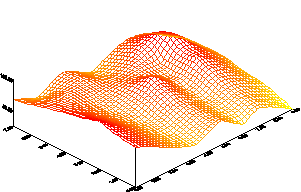
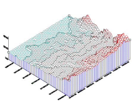
definitions Grid is the one of all data providing for digital terrain or elevation model, otherwise also another continuous data. The data have grid format. According Gibaeu (2000), a grid defines geographic space as a matrix of identically sized square cells. Each of cells holds a numeric value that measures geographic attribute for that unit of space. For example, elevation data value will store for each set of regularly spaced ground positions, so that each data point represent the elevation of the grid cell in which each of location. About it often called Digital Elevation Model (DEMs). The value each of cell will give assign with color of cell (often in ArcView method) or line (Surfer method) when the grid had been drawing. The smaller distance between point will give more detail figure or model convey, because when interpolation process to fill the blank space will more accurate or low error to predict the value. Figure 2 as show the result figure from grid data using Surfer method. |
Figure 2. Sample of 3d surface from grid data using Surfer method |
|
Figure 3. Ilustration the cell will be interpolation to fill the unknown value |
Grid
Processing
If we have the data contained z value, we can create grid data.
Value each of cell will be interpolated to determine the unknown
data between points that have z value.
In this case, interpolation can define as the procedures of
predicting or calculating unknown values using the known data values at
neighborhood locations. To
interpolate, some software have been established algorithm.
Figure 3 as show how and where the cell will be give the value as
interpolation result. The result of interpolation will be influencing some factors
and they also determine the quality of interpolation. They are accuracy of data, number of data (not all many data
will give the good quality interpolation, it is depend on distribution of
data), distribution of known points and how well the mathematically
function that used to interpolation, because in the some software we can
select it function. So that
considering from those factor, we must to understanding about data
characteristic and objective of interpolation so that we can determine
mathematically function will be used.
|
In the ArcView method available mathematically function like as Inverse Distance Weight (IDW) and spline. IDW assume by each of point has a local influences that disminishes with distance. Spline based on fits a curve 3D surface through the neighberouring point surrounding the cell being analyzed, and then gives the cell the value of surface at that location. In the Surfer method may have more interpolation method than ArcView such as Inverse distance to a power (IDW), Kriging, Minimum, Curvature, Polynomial Regression, Radial basis functions, Shepard’s method and Triangulation with linear interpolation.
Type
of grid
Grid data have two type, there are integer grid and floating points grid. Integer grid defines by stored cell as integer and floating pint grids define by grids stored with decimal points. To choose type of grid we should consider about data being represented, one or the other may be more appropriate. Often continuous data represent by floating point, but it’s type can convert to integer depend on objective when we will presentation. Other differences both of grid type are integer grids have attribute tables but floating point does not have it. Information about data type is important to displayed, symbolized and analyzed in 3D analyst.
Grid
analysis
Surface
analysis using grid approaches can be used to presentation some element of
surface, especially elevation data or information.
Their elements are characteristics of flow direction, contours, slope and
aspect also to viewer such as viewshed, hillshading and perspective.
Sometimes using ArcView method, grid data can be used for 3D terrain
visualization and simulation of terrain, it also be used as base surface for
other feature if we want like as vectors and image data.
|
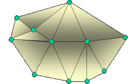
Figure 2.3. Sample of TIN |
2.
Triangulation Irregularly Networks (TIN) TIN
definitions Some times, when we create GIS project using surface we only have discrete data. Actually from the theory we cannot direct create surface. TIN data model give solving problem it. Using TIN, makes possible for set data points to be represented as a continuous surface. It is replication of much of the functionality of grids in a vector context. As simply, TIN is geometric term that a set vertices or point that are connected by edges that from triangle dimension as shown in Figure 4. TIN model will make height between points or node can be interpolated thus allowing the definition of a continuous data. TIN have two element for data structure; first, a set of input points with X,Y, Z values and second is a series of edges connecting these point to form triangle. Data input each of point will be changes into the node of a triangle and the output is a continuous face surface of triangles (see Fig,2.3). Connecting between nodes neighborhood will be closed area and became triangle polygon. Refer from explanation how TIN processing we could say that a TIN has a more complex data structure data structure than grid. Because it must stored 3D coordinate for each point or nodes and maintain appropriate topological relationship between adjacent triangles.
|
|
TIN
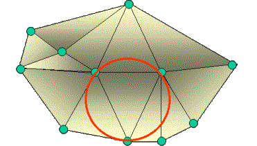
processing Like as on above explanation, we have been known that TIN processing is connecting the data points. It process called tessellate, it is filling plane with repetitions of figures in away that this place not have information. Triangulation generated based on Delaunay triangulation mathematical technique. It is can be define that a circle drawn from the three points of any triangle will contain no other input point. It is give guaranteed that the polygon of triangle no overlap with the other polygons, it is will be generated one by one triangle each of point with neighborhood point as shown in Figure 2.4. The output TIN processing can make possible for interpolation zvalue for any location a TIN surface using the XYZ valueof the bounding triangle points. We also fill additional information with calculate for each face such as slope, aspect and surface area.
|
Figure 2.4. Delaunay approach
|
Type of TIN
Like as Grid approach, TIM data model also have the specific type for processing especially about how the data will be manage or surface feature type of output process. A surface feature type influences the triangulation and thus the definition of the resulting output. Any surface feature type that can crate using TIN data model using ArcVIew method are; Mass Points, Breaklines, Replace Polygon, Erase Polygon, Clip Polygon, and Fill Polygon. Each of type surface use to specified data. Foe example like as mass point will be used to generate TIN form contour data, breaklines type for road, river or another line type data and Replace polygon for lake or other polygon data type.
TIN
analysi
Surface analysis using TIN approaches can be used to presentation some element of surface. Their elements are characteristics of flow direction, contours, slope and aspect also to viewer such as viewshed, hillshading and perspective. Sometimes using ArcView method, TIN data can be used for 3D terrain visualization and simulation of terrain, it also be used as base surface for other feature if we want like as vectors and image data.
DISCUSSION
This chapter will be discussing about the result of surface analyses off all steps. The main subject for discussion is comparison surface analysis as the result from TIN and Grid data model. So that, to make systematically of discussion will be explain step by step such as Result of All Analysis Chapter.
More discussion....Still Under constructions
![]()
![]()
![]()